GLOBEC Program
Research results on Barkley Canyon
Sixteen stations were sampled in Barkley Canyon during a research cruise in July 1997. CTD casts were performed in most of them but also zooplankton tows. Here are some preliminary results. In addition, four moorings were deployed and provided us with time-series of current data, temperature and salinity. If you are interested in finding out more, please send me an email at the adress shown at the bottom of this page.
All 16 stations show similar profiles of temperature, salinity and density. The temperature decreases with depth and ranges between 15-16 degC at the surface to 6 degC around 400 m (at BCE4 for instance) and 4 degC around 800 m (at BCC4). The salinity increases with depth as does the density and it ranges between 30.5 at the surface to 34 from around 140 m to 400 m (it appears to be almost constant in that depth range). From 600 m to 800 m, it passes over 34. The density, which profile is similar to the one of salinity, ranges from 22.5 at the surface to around 26.5, reaching over 27 at 700-800 m.
Profiles of temperature vs salinity (T/S diagrams) were also ploted for each station. Most of them show a separation between the surface waters (well mixed, high temperature and low salinity) and the deep Pacific waters (low temperature and high salinity). In Figure 1, some very interesting features appear. For instance, there is a clear separation between the warmer and saltier offshore surface waters (top cluster of mainly dotted lines) and the inshore one. Most of the stations have the same behaviour around a nodal point of salinity 32.5 and temperature 8.5, which separates the surface water from a second water mass. The position of this nodal point is found around 60 m deep for the offshore stations but 50 m deep for the inshore ones (showing that the water from the mouth of the canyon upwells towards its head). The offshore waters tend to propagate towards the shore and the solid blue line (for BCA1) shows some intrusion of offshore water (around 10 degC and 32 ppt). Beyond that nodal point, there is water which tends to be mix between the water mass mentioned earlier, present around 50-60 m and another water mass (6.9 degC, 33.9 ppt) originating from 200 m in the deeper parts of the canyon.
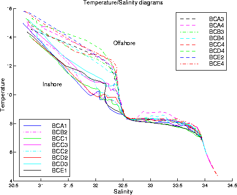
Fig.1: Temperature/Salinity diagrams for all stations (refer to the figure for the colour codes).
The summer winds on the West Coast of Vancouver Island are known to be upwelling-favorable and cause coastal upwelling. Moreover, the interaction of the canyon with the southward-flowing Shelf-Break Current induces an enhanced upwelling within the canyon and in its vicinity. Looking at the across-shore lines, it can be seen that the isopleths dome in the center of the canyon, close to the surface at around 20 m deep. The upwelling is stronger towards the head, at depths between 40 and 120 m. The upwelling is also stronger within the canyon: the vertical displacement of the isohalines is weaker at the farther-upstream line and at the farther-downstream one. Considering the alongshore lines, the isopleths still dome at the center of the canyon in the first 30 m. Close to the head, the 8 degC isotherm is upwelling from the northern, upstream side to the southern, downstream side. In the middle of the canyon, the isopleths tend to bulge down between two stations when the depth plunges from 200 to 600 m.
The depths of various isohalines are also analysed. In Figure 2, the isohaline 31.5 is usually found between 10 and 14 m deep, presenting a dome above the head of the canyon, and particularly on the downstream side. This dome is associated with the enhanced upwelling triggered by the canyon. The increase in depth shoreward is due to the Vancouver Island Coastal Current. Upwelling is noticeable as well in the 32.5 isohaline. This isohaline is between 44 and 54 m deep and also becomes shallower on the downstream side, at the head of the canyon. The upwelling is visible on the shelf as well. The 33 isohaline also shows upwelling at the head, with a depth as shallow as 70 m. It is deepest (82-84 m deep) on the upstream side, by the mouth.
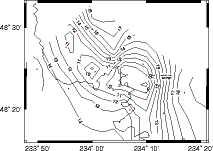
Fig.2: Depth of the 31.5 isohaline around the canyon (the 200-m isobath is shown).
As far as winds are concerned, during the Spring Transition (April-May), the wind direction shows a lot of variability changing from mainly northwest (winter pattern) to southeast (summer pattern). Starting in the middle of June to middle August, the wind becomes less variable and aligns mainly with the southeast, as expected. There is an abrupt and clear reversal event from around August 20th until the beginning of September when the wind suddenly turns back to its winter pattern. But in general, the period September-October is characteristic of the Fall Transition, with the wind showing again a lot of variability and starting to turn back to the northwest.
The current data from the moorings also shows a lot of variability. Overall, the picture is consistent with cyclonic circulation within the canyon but the currents' directions do show large fluctuations. Figure 3 presents the colour-coded monthly-averaged currents for July: the red currents are at 150 m, the green at 250 m and the blue at 350 m.
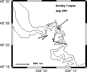
Fig.3: Monthly-averaged currents at 150, 250 and 350 m (red, green and blue respectively) from BC01, BC02, BC03 and BC04 for July 1997. The 200-, 300- and 400-m isobaths are shown.
Finally, when looking at the time-series of temperature and salinity, three major upwelling events can be found in mid-June, end of July and early September. The temperature decreases slightly during these events and the four moorings behave differently. Also some lag (up to 5 days) can be observed between the deep sensors and the shallower ones. Upwelling events in Barkley Canyon are definitely sporadic and weak. Figure 4 presents the time-series of temperature at mooring BC04.
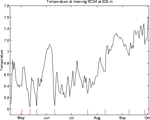
Fig.4: Daily-averages of the temperature (degC) from BC04 at 230 m, from April 19th until October 1st, 1997. The red lines denote important upwelling events.
As far as the zooplankton are concerned, most species were found abundantly in the 50-m day tows. In general, migratory species were found closer to the head while passive species were more abundant at the mouth. Swimming species are believed to combine vertical migration with current patterns to remain in favorable environments. With high nutrient and phytoplankton supply, the head of the canyon would be the most favorable environment for them. Also the deep circulation (up-canyon) would facilitate a return to the head. Figure 5 presents the expected aggregation pattern of zooplankton, as well as the observed canyon study results.
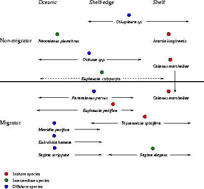
Fig.5: Chart of the species' region preferences (from D. Mackas, pers. comm.) and of the canyon study results (dots). Species found at the head are marked with a red dot, those at the mouth with a blue dot, and species with a green dot are equally abundant at both locations.
If you are interested in more details, please email me.
